Jungle Habitat is a former safari park and zoo in West Milford. The park only operated briefly between 1972 and 1976 before shutting down. Today, the remains of the facility include animal cages, an old ride track, and winding safari roads. In the decades since the park closed, there have been numerous unsubstantiated rumors of escaped animals such as tigers roaming the woods of North Jersey. For more information on the park’s history, a group of locals has created a website named West Milford Jungle Habitat, featuring a timeline of the park and interviews with locals and former employees. Fortunately, unlike many abandoned sites, Jungle Habitat is located on public state land as an annex of Long Pond Ironworks State Park, and visitors are welcome to explore the property. The property is large and sprawling, giving explorers many places to wander. Because of the size and confusing nature of the old roads, this park is best for people familiar with GPS and comfortable with navigation.
Long Pond Ironworks State Park
Other Attractions: Long Pond Historic District, Monksville Reservoir
The Zoo Area
The former zoo area of the park is where visitors were once able to get out of their cars and walk between exhibits, similar to most zoos. Aside from the animal exhibits, there was at least one ride with visible remains at the park. There are marked trails at Jungle Habitat, but the best way to explore the park is to simply wander around the numerous unmarked paths. I highly recommend using a GPS mapping service to help navigate the park.
To reach the zoo section of the park, walk past the gate and travel along the paved former park entrance. In about half a mile, you will arrive at what used to be Jungle Habitats’ massive parking area.

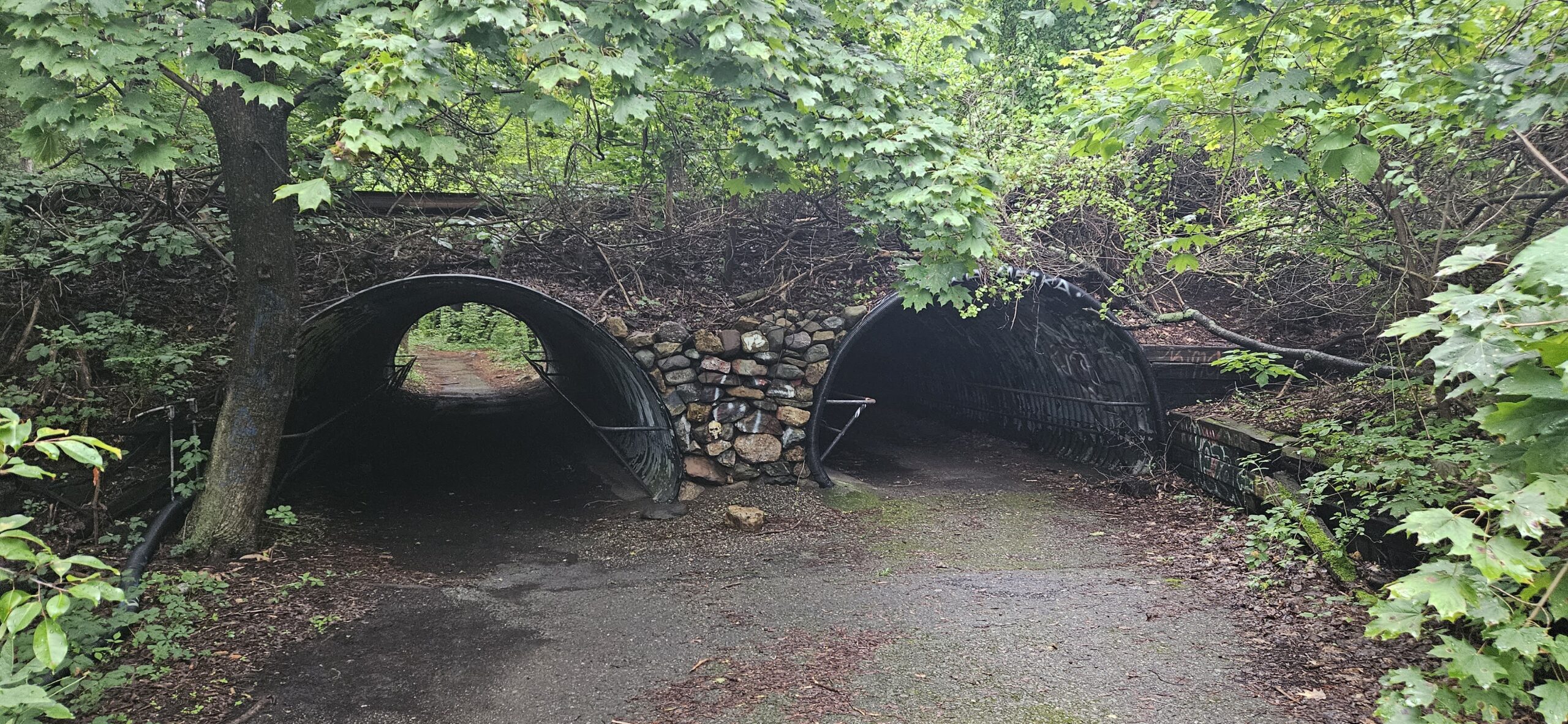
When you reach the parking area, you will see a paved trail marking a sharp left turn. Do not take this trail yet, as it leads to the drive-through safari portion. After walking into the parking area, you will see another paved trail on the left. Once again, do not take this trail either, as it does not provide access to the zoo itself, instead passing over the entrance tunnels. Instead, continue walking until you see another paved trail on the left and the former entrance tunnels. Finally, you have reached the correct entrance. The turn is located at 41.12191, -74.34559. From here, you will have access to many former pathways. Some of these trails are extremely obvious, while others are eroded and overgrown. It is best to try and take many of these trails, as some interesting sights are unfortunately on the overgrown trails. A selection of highlights are listed below, but it is best to explore the place freely without a plan. Due to the complex and overlapping unmarked and unmaintained trail network, only the GPS coordinates are listed.


The Drive-Through Safari
The star attraction of Jungle Safari was arguably the drive-through safari. For those familiar with the Wild Safari at Six Flags Great Adventure, especially when you could drive yourself through, the Jungle Habitat Safari was essentially the same thing. You can quickly access the safari section from a short trail near the current parking lot gate. To get the best sense of what the park used to be like, it is recommended to walk towards the former parking area, which is straight through the current gate. Once you reach the parking area, if you make a very sharp left turn, you will enter the former safari area. Here you will find large fencing to keep the animals in, and retractable gates to let the cars enter.

As with the zoo section of the park. The best way to explore this section is by following the former park roads. The roads gently snake their way up the hillside, entering many former enclosures. As an alternative to the roads, there are also a handful of marked and unmarked footpaths passing through the area. Many of the old roads are very obvious and easy to follow. Unfortunately, many roads are also very overgrown. At sections where the road splits, it is not always immediately obvious which trail is more passable.

Additional Information
- The park has been going through a re-blazing to provide better access for mountain bikers. Many of the mountain bike trails go around many of the more interesting sites, so it may be best to explore the place by foot and stick to the unmarked trails.
- As stated numerous times above, the trail network is confusing without a GPS map. Use a GPS app to help navigate
- Some of the trails are easily passable, while some are very overgrown. Be aware of ticks. Fortunately, because many trails were paved, the park does not get muddy in the overgrown sections.
Leave a Reply